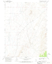
1969 Map of Gilbert Creek NE
USGS Topo · Published 1971About this map
Antelope Valley dominates this 1969 topographic study, revealing a sparsely populated Nevada landscape defined by its high desert basins and isolated peaks. Located in Lander County, the map documents the region's limited industrial and water infrastructure, essential for survival in the Great Basin. Evidence of resource exploration is visible at a Prospect and a Gravel Pit, while the placement of several Well sites suggests the importance of underground water sources for ranching or mining operations. Prominent landmarks such as Red Butte and Antelope Butte break the wide expanse of the valley floor. The map also meticulously records ranching infrastructure, using fine dashed lines to indicate selected fence lines that divide the open range, providing a precise record of land use before more modern developments altered the high-desert character of the area.
Find a feature on this map
7 named features on this map. Tap any name to fly to it.
Don’t see what you’re looking for? This feature index may not catch every label — zoom into the map to look around manually.
Map Details
Editions of this 1969 Gilbert Creek NE Map
This is the sole edition of this map. No revisions or reprints were ever made.
Other maps of this area

1932 · Sonoma Range
USGS Topo · 1:250,000

1939 · Sonoma Range
USGS Topo · 1:250,000

1955 · Millett
USGS Topo · 1:250,000

1955 · Winnemucca
USGS Topo · 1:250,000

1958 · Winnemucca
USGS Topo · 1:250,000

1959 · Millett
USGS Topo · 1:250,000

1961 · The Cedars
USGS Topo · 1:62,500

1961 · Mt. Moses
USGS Topo · 1:62,500

1962 · Winnemucca
USGS Topo · 1:250,000

1969 · Manhattan Mtn
USGS Topo · 1:24,000