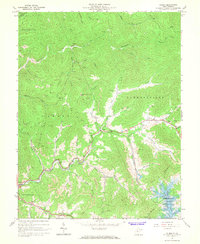
1967 Map of Gilboa
USGS Topo · Published 1968About this map
Gilboa and the surrounding Nicholas County highlands are defined here by a deeply dissected landscape of steep ridges and winding watercourses like Twentymile Creek and Peters Creek. During the late 1960s, the region was in a period of transition as the massive Summersville Lake reservoir began to reshape the southeastern corner of the quadrangle. Extensive strip mines are visible across the hills, signaling the intense industrial scale of coal extraction in the Grant and Jefferson districts.
Find a feature on this map
49 named features on this map. Tap any name to fly to it.
Don’t see what you’re looking for? This feature index may not catch every label — zoom into the map to look around manually.
Map Details
Editions of this 1967 Gilboa Map
3 editions found
Other maps of this area

1889 · Nicholas
USGS Topo · 1:125,000

1891 · Nicholas
USGS Topo · 1:125,000

1897 · Kanawha Falls
USGS Topo · 1:125,000

1900 · Kanawha Falls
USGS Topo · 1:125,000

1901 · Nicholas
USGS Topo · 1:125,000

1901 · Kanawha Falls
USGS Topo · 1:125,000

1908 · Clay
USGS Topo · 1:48,000

1908 · Fayetteville
USGS Topo · 1:48,000

1910 · Clay
USGS Topo · 1:62,500

1910 · Fayetteville
USGS Topo · 1:62,500