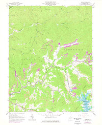
1967 Map of Gilboa
USGS Topo · Published 1977About this map
Gilboa and the surrounding Nicholas County highlands are defined here by a heavy industrial footprint during the late 1960s and 1970s. The landscape is marked by extensive Strip Mines and dozens of Gas Well sites, particularly concentrated around the Neff Fork and Buck Garden Creek drainages. A clear infrastructure of resource extraction is evident, from the Conrail line following Peters Creek to the various unnamed haul roads and trails. The map documents a community deeply rooted in its geography, with local landmarks like the Lone Star Lookout Tower and family-named sites such as McCutchin Cem and Keenan Cem. Near the southeast corner, the rising waters of Summersville Lake meet the mouth of McKee Creek, showing the impact of modern water management on this traditional coal and gas territory. Small hamlets like Zela, Drennen, and Poe remain connected by rural routes and churches like Salem Ch and Pierson Chapel.
Find a feature on this map
51 named features on this map. Tap any name to fly to it.
Don’t see what you’re looking for? This feature index may not catch every label — zoom into the map to look around manually.
Map Details
Editions of this 1967 Gilboa Map
3 editions found
Other maps of this area

1889 · Nicholas
USGS Topo · 1:125,000

1891 · Nicholas
USGS Topo · 1:125,000

1897 · Kanawha Falls
USGS Topo · 1:125,000

1900 · Kanawha Falls
USGS Topo · 1:125,000

1901 · Nicholas
USGS Topo · 1:125,000

1901 · Kanawha Falls
USGS Topo · 1:125,000

1908 · Clay
USGS Topo · 1:48,000

1908 · Fayetteville
USGS Topo · 1:48,000

1910 · Clay
USGS Topo · 1:62,500

1910 · Fayetteville
USGS Topo · 1:62,500