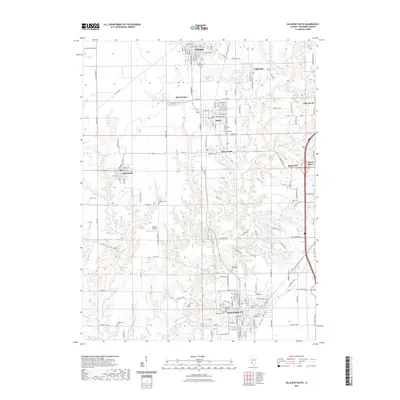
2021 Map of Gillespie South
USGS Topo · Published 2021About this map
Staunton and its northern neighbors anchor this Macoupin County landscape, where the density of small settlements reflects a legacy of regional industry and coal mining. The terrain is defined by a network of waterways including Cahokia Creek and Ginseng Creek, which carve through the land between towns like Benld, Gillespie, and Sawyerville. For genealogists, the map is remarkably dense with burial grounds, ranging from the Old Saint Michaels Cemetery and Saint Michaels Cemetery in the south to the Tine Sawyer Cemetery near the center. The presence of the Mine Number 7 Reservoir east of Staunton and several private club lakes, such as Forest Lake Club Lake, highlights how former industrial footprints and recreational developments have reshaped the local geography. Smaller enclaves like White City and Eagarville further illustrate the clustered settlement patterns typical of this Illinois coal country.
Find a feature on this map
161 named features on this map. Tap any name to fly to it.
Don’t see what you’re looking for? This feature index may not catch every label — zoom into the map to look around manually.
Map Details
Editions of this 2021 Gillespie South Map
This is the sole edition of this map. No revisions or reprints were ever made.
Other maps of this area

1912 · Gillespie
USGS Topo · 1:62,500

1915 · Gillespie
USGS Topo · 1:62,500

1915 · Mount Olive
USGS Topo · 1:62,500

1927 · Edwardsville
USGS Topo · 1:62,500

1932 · Edwardsville
USGS Topo · 1:62,500

1937 · New Douglas
USGS Topo · 1:48,000

1944 · New Douglas
USGS Topo · 1:62,500

1944 · Mount Olive
USGS Topo · 1:62,500

1954 · Worden
USGS Topo · 1:24,000
1954 · Prairietown
USGS Topo · 1:24,000