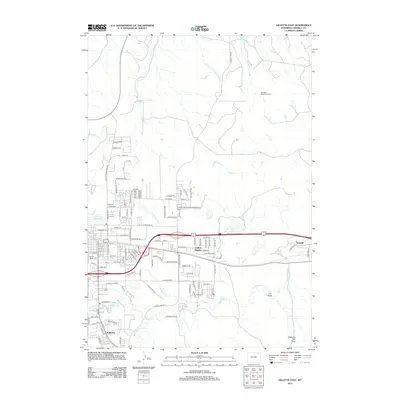
2012 Map of Gillette East
USGS Topo · Published 2012About this map
Collins Heights and Wyodak sit at the intersection of industry and burgeoning residential development in this early 21st-century Wyoming landscape. The eastern outskirts of the city show a complex infrastructure designed for resource extraction and water management, anchored by the Springen Ranch Oil Field to the north and the Burlington Northern Santa Fe railroad corridor. Significant water features such as the Gillette Reservoir and Gillette Fishing Lake contrast with the natural drainage of the Dry Fork Little Powder River and Donkey Creek. Local history is anchored at the Mount Pisgah Cem, while the expansive network of named draws, including Lee Draw and Shearing Pen Draw, reveals the natural topography underlying the modern street grid of neighborhoods like Sunburst.
Find a feature on this map
118 named features on this map. Tap any name to fly to it.
Don’t see what you’re looking for? This feature index may not catch every label — zoom into the map to look around manually.
Map Details
Editions of this 2012 Gillette East Map
This is the sole edition of this map. No revisions or reprints were ever made.
Other maps of this area

1954 · Gillette
USGS Topo · 1:250,000

1955 · Gillette
USGS Topo · 1:250,000

1958 · Gillette
USGS Topo · 1:250,000

1962 · Gillette
USGS Topo · 1:250,000

1971 · Coyote Draw
USGS Topo · 1:24,000

1971 · Gillette East
USGS Topo · 1:24,000

1971 · Green Hill
USGS Topo · 1:24,000
1971 · The Gap
USGS Topo · 1:24,000
1971 · Appel Butte
USGS Topo · 1:24,000
1971 · Gillette West
USGS Topo · 1:24,000