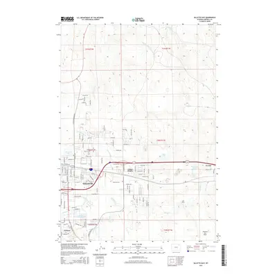
2015 Map of Gillette East
USGS Topo · Published 2015About this map
Gillette serves as the focal point of this 2015 survey, illustrating the city's residential expansion and industrial infrastructure. The eastern edge of the community is anchored by Collins Heights and the smaller Sunburst development, while the BNSF Railway corridor dictates the movement of resources through the region. Significant water management features are evident at the Wyodak Ash Pond Reservoir and Burlington Lake, reflecting the intersection of municipal growth and energy production at Wyodak.
Find a feature on this map
118 named features on this map. Tap any name to fly to it.
Don’t see what you’re looking for? This feature index may not catch every label — zoom into the map to look around manually.
Map Details
Editions of this 2015 Gillette East Map
This is the sole edition of this map. No revisions or reprints were ever made.
Other maps of this area

1954 · Gillette
USGS Topo · 1:250,000

1955 · Gillette
USGS Topo · 1:250,000

1958 · Gillette
USGS Topo · 1:250,000

1962 · Gillette
USGS Topo · 1:250,000

1971 · Coyote Draw
USGS Topo · 1:24,000

1971 · Gillette East
USGS Topo · 1:24,000

1971 · Green Hill
USGS Topo · 1:24,000
1971 · The Gap
USGS Topo · 1:24,000
1971 · Appel Butte
USGS Topo · 1:24,000
1971 · Gillette West
USGS Topo · 1:24,000