
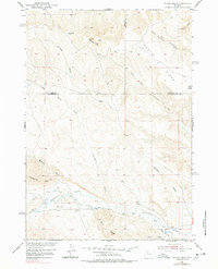
1951 Map of Gillies Draw
USGS Topo · Published 1953About this map
Gooseberry Creek and its complex system of irrigation infrastructure anchor the southern portion of this high-desert landscape in the early 1950s. The presence of the Quartz Pipe Line Ditch, Pine Tree Extension Ditch, and Gillies Ditch reflects the critical role of water management in supporting ranching and agricultural efforts within the Missouri River Basin development area. To the north, the terrain is defined by dramatic geological features such as the twin peaks of Squaw Teats and the prominent Sawtooth ridge. The map also captures several county boundaries, showing where Park, Washakie, and Hot Springs Counties meet amidst the draws and ridges. Of particular note for historians is the Murphy Ditch (Abandoned), which provides a rare physical record of earlier, lapsed attempts to divert water across the drainage divides near Murphy Draw.
Find a feature on this map
24 named features on this map. Tap any name to fly to it.
Don’t see what you’re looking for? This feature index may not catch every label — zoom into the map to look around manually.
Map Details
Editions of this 1951 Gillies Draw Map
2 editions found
Other maps of this area

1913 · Grass Creek Basin
USGS Topo · 1:62,500

1914 · Blue Mesa
USGS Topo · 1:62,500

1915 · Grass Creek Basin
USGS Topo · 1:62,500

1916 · Blue Mesa
USGS Topo · 1:62,500

1951 · Hillberry Rim
USGS Topo · 1:24,000

1951 · Dutch Nick Flat SW
USGS Topo · 1:24,000

1951 · Wilson Spring
USGS Topo · 1:24,000

1951 · Dead Indian Hill
USGS Topo · 1:24,000

1951 · Dutch Nick Flat NW
USGS Topo · 1:24,000

1955 · Cody
USGS Topo · 1:250,000