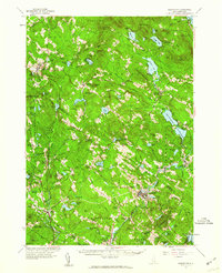
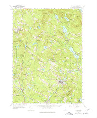
1957 Map of Gilmanton
USGS Topo · Published 1960About this map
Gilmanton Ironworks and the surrounding township anchor this mid-century topographic record, which reveals a landscape defined by New Hampshire's central lakes and ridges. This 1957 revision updates a network of local settlements like Lower Gilmanton and Loudon Ridge, where the presence of the Loudon Ridge Sch and the Academy highlight the area's established educational roots. The map is particularly rich in religious and communal history, marking the Shaker Village at the western edge and historic sites such as the Smith Meeting House and the Friends Meetinghouse in Epsom.
Find a feature on this map
118 named features on this map. Tap any name to fly to it.
Don’t see what you’re looking for? This feature index may not catch every label — zoom into the map to look around manually.
Map Details
Editions of this 1957 Gilmanton Map
5 editions found
Other maps of this area

1909 · Winnepesaukee
USGS Topo · 1:62,500

1917 · Mt. Pawtuckaway
USGS Topo · 1:62,500

1919 · Mt. Pawtuckaway
USGS Topo · 1:62,500

1919 · Gilmanton
USGS Topo · 1:62,500

1919 · Alton
USGS Topo · 1:62,500

1921 · Suncook
USGS Topo · 1:62,500

1925 · Holderness
USGS Topo · 1:62,500

1927 · Concord
USGS Topo · 1:62,500

1927 · Penacook
USGS Topo · 1:62,500

1927 · Gilmanton
USGS Topo · 1:62,500