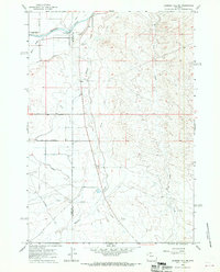
1966 Map of Gilmore Hill NE
USGS Topo · Published 1970About this map
The Shoshone River flows through the northern reaches of this Wyoming landscape, where human engineering meets the arid terrain of the Big Horn Basin. Irrigation infrastructure is central to the area's development, evidenced by the Sidon Canal and Elk Lovell Canal branching off the river to support local agriculture. The historical Bridger Trail cuts across the southwestern portion of the sheet, providing a tangible link to 19th-century overland travel routes used by emigrants and gold seekers. Near the confluence of Whistle Creek and the river valley, the Penrose Cem serves as a quiet marker of early settlement along the Park and Big Horn County line. The map also detail local drainage patterns through Coon Creek and Grass Creek, alongside industrial markers like a Gravel Pit and a Gaging Sta on the river.
Find a feature on this map
18 named features on this map. Tap any name to fly to it.
Don’t see what you’re looking for? This feature index may not catch every label — zoom into the map to look around manually.
Map Details
Editions of this 1966 Gilmore Hill NE Map
2 editions found
Other maps of this area

1955 · Cody
USGS Topo · 1:250,000

1958 · Cody
USGS Topo · 1:250,000

1962 · Cody
USGS Topo · 1:250,000

1966 · Gilmore Hill NE
USGS Topo · 1:24,000

1966 · Gilmore Hill SE
USGS Topo · 1:24,000

1966 · Garland
USGS Topo · 1:24,000

1966 · Jack Horner Reservoir
USGS Topo · 1:24,000

1966 · Gilmore Hill NW
USGS Topo · 1:24,000

1966 · Gilmore Hill
USGS Topo · 1:24,000
1966 · Lovell
USGS Topo · 1:24,000