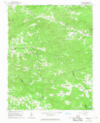
1966 Map of Gilreath
USGS Topo · Published 1968About this map
The Brushy Mountains dominate this landscape in the mid-1960s, a region defined by intricate ridges and the upper reaches of the South Yadkin River. Local life centers around a dense network of country churches and small community hubs like Gilreath and Old Gilreath. The map documents a deeply rooted rural infrastructure, where family and community landmarks are frequent, such as the Bethany Ch and its nearby Old Bethany Cem. High points across Vannoy Ridge and Fitches Knob provide vantage points for the Brushy Mountain Fire Tower, which overlooks the winding headwaters of Hunting Creek and Rocky Creek. This survey was conducted just as the modern road system began to formalize around older routes like Pike Road and Wildcat Road, preserving a detailed view of the Wilkes County backcountry before further modernization.
Find a feature on this map
43 named features on this map. Tap any name to fly to it.
Don’t see what you’re looking for? This feature index may not catch every label — zoom into the map to look around manually.
Map Details
Editions of this 1966 Gilreath Map
2 editions found
Other maps of this area

1889 · Wilkesboro
USGS Topo · 1:125,000

1891 · Wilkesboro
USGS Topo · 1:125,000

1891 · Yadkinville
USGS Topo · 1:125,000

1893 · Statesville
USGS Topo · 1:125,000

1893 · Yadkinville
USGS Topo · 1:125,000

1895 · Hickory
USGS Topo · 1:125,000

1953 · Charlotte
USGS Topo · 1:250,000

1953 · Winston-Salem
USGS Topo · 1:250,000

1954 · Charlotte
USGS Topo · 1:250,000

1955 · Winston-Salem
USGS Topo · 1:250,000