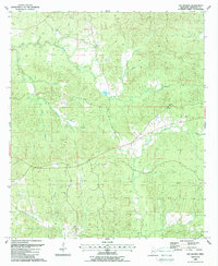
1988 Map of Gin Branch
USGS Topo · Published 1988About this map
North Fork Coles Creek and Middle Fork Coles Creek define the drainage patterns of this rural Jefferson County landscape, winding through timbered ridges toward the Homochitto River in the south. The 1988 survey, based on revisions from mid-1980s aerial photography, documents a quiet agricultural and wooded district where small community hubs like Ephesus Ch and Bethesda Ch serve as local landmarks. The presence of the Dillon Cem near the northern boundary and the Crown Point Ch further south highlights the deep-rooted settlement history of the area.
Find a feature on this map
18 named features on this map. Tap any name to fly to it.
Don’t see what you’re looking for? This feature index may not catch every label — zoom into the map to look around manually.
Map Details
Editions of this 1988 Gin Branch Map
This is the sole edition of this map. No revisions or reprints were ever made.
Other maps of this area

1939 · Lorman
USGS Topo · 1:62,500

1953 · Natchez
USGS Topo · 1:250,000

1956 · Natchez
USGS Topo · 1:250,000

1958 · St. Joseph
USGS Topo · 1:62,500

1959 · Natchez
USGS Topo · 1:250,000

1962 · Fayette
USGS Topo · 1:62,500

1963 · Red Lick
USGS Topo · 1:24,000

1963 · Union Church
USGS Topo · 1:62,500

1963 · McBride
USGS Topo · 1:24,000
1984 · Natchez
USGS Topo · 1:100,000