
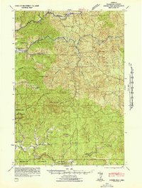
1942 Map of Ginger Peak
USGS Topo · Published 1942About this map
Nestucca River and Trask River headwaters define this wartime landscape within the Siuslaw National Forest. During the early 1940s, the terrain was heavily utilized for government-led resource management and infrastructure projects, evidenced by the presence of WPA Camp Wilson No 1 and CCC Camp Trask. These camps, along with several lookouts like Square Top Lookout and Edwards Butte Lookout, reflect the era's focus on fire suppression and forest labor in the Coast Range.
Find a feature on this map
42 named features on this map. Tap any name to fly to it.
Don’t see what you’re looking for? This feature index may not catch every label — zoom into the map to look around manually.
Map Details
Editions of this 1942 Ginger Peak Map
2 editions found
Other maps of this area

1937 · Nehalem
USGS Topo · 1:62,500

1937 · Enright
USGS Topo · 1:62,500

1941 · Nestucca Bay
USGS Topo · 1:62,500

1941 · Timber
USGS Topo · 1:62,500

1941 · Enright
USGS Topo · 1:62,500

1942 · Sheridan
USGS Topo · 1:62,500

1942 · Spirit Mtn
USGS Topo · 1:62,500

1942 · Nestucca Bay
USGS Topo · 1:62,500

1942 · Fairdale
USGS Topo · 1:62,500

1942 · Tillamook
USGS Topo · 1:62,500