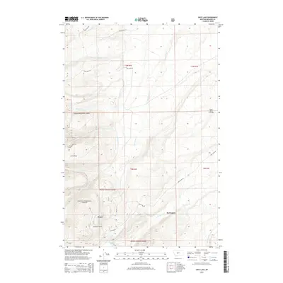
2014 Map of Gipsy Lake
USGS Topo · Published 2014About this map
Helena National Forest dominates the western half of this Meagher County landscape, where steep drainages flow toward the high alpine basins of the Big Belt Mountains. The settlement of Manger sits near the head of Thompson Gulch, serving as a waypoint along Duck Creek Rd at the forest boundary. Further east, the terrain opens into the higher ridges of Camas Ridge and the broad flats of Upper Birch Creek Bar. This 2014 survey documents a network of forest service roads, including Camas Creek Rd and Alanta Creek Rd, which provide access to the remote creeks and peaks. The map reveals the hydrology of the region, from the secluded waters of Gipsy Lake and Gipsy Cr to the larger flows of Big Birch Cr, illustrating how the land's rugged topography dictates the placement of isolated settlements like Buckingham.
Find a feature on this map
29 named features on this map. Tap any name to fly to it.
Don’t see what you’re looking for? This feature index may not catch every label — zoom into the map to look around manually.
Map Details
Editions of this 2014 Gipsy Lake Map
This is the sole edition of this map. No revisions or reprints were ever made.
Other maps of this area
1886 · Fort Logan
USGS Topo · 1:250,000
1948 · White Sulphur Springs
USGS Topo · 1:250,000
1950 · Duck Creek Pass
USGS Topo · 1:62,500
1958 · White Sulphur Springs
USGS Topo · 1:250,000
1961 · White Sulphur Springs
USGS Topo · 1:250,000
1965 · White Sulphur Springs
USGS Topo · 1:250,000
1966 · Boulder Baldy
USGS Topo · 1:24,000
1966 · Watson
USGS Topo · 1:24,000
1971 · Whitetail Reservoir
USGS Topo · 1:24,000
1971 · Mount Edith
USGS Topo · 1:24,000