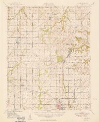
1949 Map of Girard
USGS Topo · Published 1949About this map
Girard anchors the southern portion of this landscape, serving as a hub where the St Louis San Francisco and Atchison Topeka and Santa Fe railroads intersect. The map reveals an exceptionally dense network of rural infrastructure across Bourbon and Crawford counties, characterized by a nearly uniform distribution of country schools and churches. Names like Lone Elm Sch, Star of Hope Sch, and Salem Sch reflect the community centers of this post-war agricultural era.
Find a feature on this map
62 named features on this map. Tap any name to fly to it.
Don’t see what you’re looking for? This feature index may not catch every label — zoom into the map to look around manually.
Map Details
Editions of this 1949 Girard Map
2 editions found
Other maps of this area

1884 · Fort Scott
USGS Topo · 1:125,000

1886 · Joplin
USGS Topo · 1:125,000

1886 · Iola
USGS Topo · 1:125,000

1886 · Fort Scott
USGS Topo · 1:125,000

1886 · Parsons
USGS Topo · 1:125,000

1893 · Fort Scott
USGS Topo · 1:125,000

1893 · Iola
USGS Topo · 1:125,000

1893 · Parsons
USGS Topo · 1:125,000

1894 · Joplin
USGS Topo · 1:125,000

1904 · Iola
USGS Topo · 1:125,000