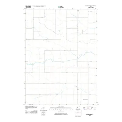
2010 Map of Gladbrook NE
USGS Topo · Published 2010About this map
Wolf Creek meanders through the heart of this Tama County landscape, defining the local drainage patterns and topography in an area characterized by a rigorous grid of section lines and county roads. The settlement history of the region is anchored by Collins Grove and the associated Collins Grove Post Office, providing a specific point of reference for genealogists tracing ancestors in this part of Iowa. The map also documents two significant burial grounds, Dinsdale Cemetery to the north and Bakers Grove Cemetery in the southern portion, which serve as vital landmarks for local history research. These sites, along with the courses of Salt Creek, Twelvemile Creek, and Fourmile Creek, illustrate the intersection of pioneer-era hydrology and early 21st-century rural infrastructure.
Find a feature on this map
22 named features on this map. Tap any name to fly to it.
Don’t see what you’re looking for? This feature index may not catch every label — zoom into the map to look around manually.
Map Details
Editions of this 2010 Gladbrook NE Map
This is the sole edition of this map. No revisions or reprints were ever made.
Other maps of this area

1954 · Waterloo
USGS Topo · 1:250,000

1955 · Waterloo
USGS Topo · 1:250,000

1963 · Buckingham
USGS Topo · 1:24,000

1971 · Gladbrook NE
USGS Topo · 1:24,000

1971 · Lincoln
USGS Topo · 1:24,000

1971 · Traer
USGS Topo · 1:24,000
1971 · Clutier
USGS Topo · 1:24,000

1971 · Reinbeck
USGS Topo · 1:24,000

1971 · Garwin
USGS Topo · 1:24,000
1971 · Gladbrook SE
USGS Topo · 1:24,000