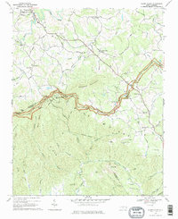
1968 Map of Glade Valley
USGS Topo · Published 1978About this map
The Blue Ridge Mountains dominate this 1960s landscape along the Alleghany and Wilkes county line, where the Blue Ridge Parkway winds through the high terrain. Notable overlooks like Mahogany Rock Overlook and Bullhead Mtn Overlook offer vantage points over a network of hollows and ridges, including Scott Ridge and Rich Mountain. Rural life is centered around the community of Glade Valley and scattered country churches, including New Salem Church, Pine Swamp Church, and Macedonia Church. The area’s water power is evidenced by the Little Glade Millpond on Glade Creek, while recreational facilities like the Ymca Camp Cheerio and Camp Albert Butler reflect the mid-century development of the mountains for seasonal use. Geologically significant features such as Stone Mountain and Wolf Rock define the southern portion of the quadrangle.
Find a feature on this map
66 named features on this map. Tap any name to fly to it.
Don’t see what you’re looking for? This feature index may not catch every label — zoom into the map to look around manually.
Map Details
Editions of this 1968 Glade Valley Map
3 editions found
Other maps of this area

1889 · Hillsville
USGS Topo · 1:125,000

1889 · Wytheville
USGS Topo · 1:125,000

1889 · Wilkesboro
USGS Topo · 1:125,000

1891 · Wilkesboro
USGS Topo · 1:125,000

1891 · Yadkinville
USGS Topo · 1:125,000

1892 · Hillsville
USGS Topo · 1:125,000

1892 · Wytheville
USGS Topo · 1:125,000

1893 · Yadkinville
USGS Topo · 1:125,000

1896 · Hillsville
USGS Topo · 1:125,000

1930 · Independence
USGS Topo · 1:48,000