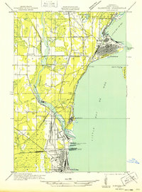
1932 Map of Gladstone SE
USGS Topo · Published 1932About this map
The industrial waterfront of Little Bay de Noc dominates this early 1930s survey, revealing a landscape shaped by the intersection of major rail lines and Great Lakes maritime commerce. Massive infrastructure including the M St P & S Ste M Docks and C & N W Docks line the shore, where the Chicago and Northwestern and several other railroads converge to meet the water. This network supported the growth of Gladstone and Wells, while smaller settlements like Kipling and West Gladstone sat at the periphery of the bustling port activity.
Find a feature on this map
46 named features on this map. Tap any name to fly to it.
Don’t see what you’re looking for? This feature index may not catch every label — zoom into the map to look around manually.
Map Details
Editions of this 1932 Gladstone SE Map
2 editions found
Other maps of this area

1932 · Gladstone NE
USGS Topo · 1:31,680

1932 · Gladstone SE
USGS Topo · 1:31,680

1932 · Rapid River NW
USGS Topo · 1:31,680

1932 · Rapid River SW
USGS Topo · 1:31,680

1932 · Gladstone SW
USGS Topo · 1:31,680

1932 · Gladstone NW
USGS Topo · 1:31,680

1950 · Gladstone NW
USGS Topo · 1:31,680

1954 · Escanaba
USGS Topo · 1:250,000

1957 · Escanaba
USGS Topo · 1:250,000

1958 · Escanaba
USGS Topo · 1:250,000