
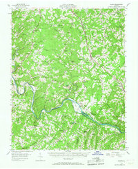
1956 Map of Gladys
USGS Topo · Published 1957About this map
The Staunton River and its companion Virginian Railway carve a distinct industrial and natural path through this portion of Southside Virginia, where the river serves as the boundary between Campbell, Pittsylvania, and Halifax counties. The landscape is defined by its rural connectivity, with the Norfolk and Western Railway intersecting at Gladys and passing through Winfall. This mid-century survey illustrates a dense network of country churches and community schools, such as William Campbell Sch and Hill Grove Sch, which anchored the small tobacco-farming settlements of the era. The topography rises toward Dry Mountain and Brown Mountain, while the river lowlands are dotted with features like Long Island and Goat I. Local industry is represented by Mitchell Mill on Seneca Creek, reflecting the traditional water-powered economies that persisted alongside the modernizing rail lines.
Find a feature on this map
89 named features on this map. Tap any name to fly to it.
Don’t see what you’re looking for? This feature index may not catch every label — zoom into the map to look around manually.
Map Details
Editions of this 1956 Gladys Map
2 editions found
Other maps of this area

1892 · Lynchburg
USGS Topo · 1:125,000

1892 · Appomattox
USGS Topo · 1:125,000

1921 · Chatham
USGS Topo · 1:48,000

1923 · Chatham
USGS Topo · 1:62,500

1944 · Lynchburg
USGS Topo · 1:62,500

1947 · Roanoke
USGS Topo · 1:250,000

1950 · Goode
USGS Topo · 1:62,500

1950 · Lynchburg
USGS Topo · 1:62,500

1951 · Altavista
USGS Topo · 1:62,500

1953 · Greensboro
USGS Topo · 1:250,000