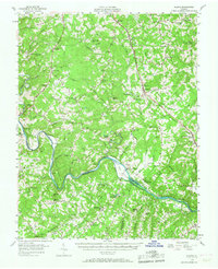
1956 Map of Gladys
USGS Topo · Published 1967About this map
The Roanoke River meanders across the southern portion of this mid-century survey, defining the border between Campbell and Pittsylvania counties. The landscape is dotted with a dense network of country churches and schools, reflecting the community structure of central Virginia in the 1950s. Settlements such as Gladys and Winfall serve as local hubs along the Norfolk and Western railroad, while the Virginian line tracks the river valley through Perrows and Long Island.
Find a feature on this map
89 named features on this map. Tap any name to fly to it.
Don’t see what you’re looking for? This feature index may not catch every label — zoom into the map to look around manually.
Map Details
Editions of this 1956 Gladys Map
2 editions found

Other maps of this area

1892 · Lynchburg
USGS Topo · 1:125,000

1892 · Appomattox
USGS Topo · 1:125,000

1921 · Chatham
USGS Topo · 1:48,000

1923 · Chatham
USGS Topo · 1:62,500

1944 · Lynchburg
USGS Topo · 1:62,500

1947 · Roanoke
USGS Topo · 1:250,000

1950 · Goode
USGS Topo · 1:62,500

1950 · Lynchburg
USGS Topo · 1:62,500

1951 · Altavista
USGS Topo · 1:62,500

1953 · Greensboro
USGS Topo · 1:250,000