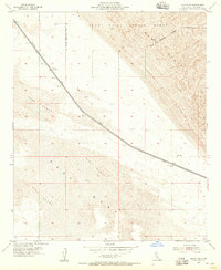
1954 Map of Glamis SE
USGS Topo · Published 1955About this map
The Coachella Canal cuts a stark, engineered line through the arid landscape of Imperial County in the mid-1950s, flanked by a protective Levee. This critical water infrastructure, which was surveyed by the USBR in the late 1930s, enabled the agricultural expansion of the region. The map highlights the intersection of military and natural geography, as the Naval Reservation Boundary encompasses a significant portion of the Sand Hills and the Impact Range to the north. South of the canal, the shifting topography of Sand Dunes gives way to the relatively flat expanse of the East Mesa. A single named crossing, Coachella Bridge No 1, provides one of the few fixed points of reference in this desolate environment, where the terrain is characterized by extensive dune fields and sparse benchmarks.
Find a feature on this map
12 named features on this map. Tap any name to fly to it.
Don’t see what you’re looking for? This feature index may not catch every label — zoom into the map to look around manually.
Map Details
Editions of this 1954 Glamis SE Map
3 editions found
Other maps of this area

1903 · Yuma
USGS Topo · 1:125,000

1905 · Yuma
USGS Topo · 1:125,000

1907 · Holtville
USGS Topo · 1:125,000

1942 · El Centro
USGS Topo · 1:250,000

1942 · Yuma
USGS Topo · 1:250,000

1953 · Grays Well
USGS Topo · 1:24,000

1953 · Ogilby
USGS Topo · 1:62,500

1953 · Cactus
USGS Topo · 1:24,000

1954 · El Centro
USGS Topo · 1:250,000

1954 · Midway Well NW
USGS Topo · 1:24,000