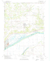
1971 Map of Glasford
USGS Topo · Published 1974About this map
The Illinois River serves as the dominant geographical and economic boundary in this early 1970s survey, separating the uplands of Timber and Logan from the bottomlands of Spring Lake. The village of Glasford stands as a central hub on the northern plateau, surrounded by the remnants of smaller 19th-century settlements like Lancaster, where the Lancaster East Sch and several family cemeteries remain. Along the river’s edge, the map documents a heavy industrial and extractive landscape, from the Strip Mine and its Tailings Ponds in the west to the Kingston River Terminal near Kingston Mines. The southern portion of the quadrangle is defined by a complex levee system protecting the agricultural tracts and the Spring Lake State Park from the river's seasonal shifts, while the Toledo Peoria and Western railroad provides a critical transportation corridor through the rugged ravines of Copperas Creek.
Find a feature on this map
42 named features on this map. Tap any name to fly to it.
Don’t see what you’re looking for? This feature index may not catch every label — zoom into the map to look around manually.
Map Details
Editions of this 1971 Glasford Map
This is the sole edition of this map. No revisions or reprints were ever made.
Other maps of this area

1905 · Peoria
USGS Topo · 1:62,500

1927 · Peoria
USGS Topo · 1:62,500

1929 · Manito
USGS Topo · 1:62,500

1930 · Glasford
USGS Topo · 1:62,500

1932 · Manito
USGS Topo · 1:62,500

1942 · Delavan
USGS Topo · 1:62,500

1948 · Glasford
USGS Topo · 1:62,500

1949 · Peoria West
USGS Topo · 1:24,000

1950 · Peoria West
USGS Topo · 1:24,000

1958 · Peoria
USGS Topo · 1:250,000