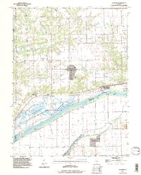
1996 Map of Glasford
USGS Topo · Published 1997About this map
Glasford serves as a central hub in this Peoria County landscape, positioned atop the bluffs overlooking the wide bottomlands of the Illinois River. The transition from the agricultural uplands to the river basin is marked by a complex network of conservation areas and industrial sites, including the Banner Marsh State Fish and Wildlife Area and the Spring Lake State Fish And Wildlife Area. Along the riverbank, the presence of the Kingston River Terminal and a nearby Gaging Station highlights the enduring importance of river navigation and management in the late 1990s.
Find a feature on this map
33 named features on this map. Tap any name to fly to it.
Don’t see what you’re looking for? This feature index may not catch every label — zoom into the map to look around manually.
Map Details
Editions of this 1996 Glasford Map
This is the sole edition of this map. No revisions or reprints were ever made.
Other maps of this area

1905 · Peoria
USGS Topo · 1:62,500

1927 · Peoria
USGS Topo · 1:62,500

1929 · Manito
USGS Topo · 1:62,500

1930 · Glasford
USGS Topo · 1:62,500

1932 · Manito
USGS Topo · 1:62,500

1942 · Delavan
USGS Topo · 1:62,500

1948 · Glasford
USGS Topo · 1:62,500

1949 · Peoria West
USGS Topo · 1:24,000

1950 · Peoria West
USGS Topo · 1:24,000

1958 · Peoria
USGS Topo · 1:250,000