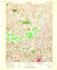
1965 Map of Glasgow North
USGS Topo · Published 1966About this map
The rolling sinkhole plain of Barren County is prominently illustrated in this mid-1960s survey, dominated by the northern expansion of Glasgow and the small agricultural and industrial nodes surrounding it. The northern reach of the Barren River Reservoir and the winding course of Beaver Creek define the lower drainage patterns, while the uplands are marked by distinct topographic features like Prewitts Knob and Flint Knob.
Find a feature on this map
33 named features on this map. Tap any name to fly to it.
Don’t see what you’re looking for? This feature index may not catch every label — zoom into the map to look around manually.
Map Details
Editions of this 1965 Glasgow North Map
This is the sole edition of this map. No revisions or reprints were ever made.
Other maps of this area

1922 · Mammoth Cave
USGS Topo · 1:62,500

1923 · Mammoth Cave
USGS Topo · 1:62,500

1926 · Scottsville
USGS Topo · 1:62,500

1935 · Horse Cave
USGS Topo · 1:48,000

1938 · Horse Cave
USGS Topo · 1:62,500

1953 · Temple Hill
USGS Topo · 1:24,000

1953 · Glasgow South
USGS Topo · 1:24,000

1954 · Evansville
USGS Topo · 1:250,000

1954 · Park
USGS Topo · 1:24,000

1954 · Horse Cave
USGS Topo · 1:24,000