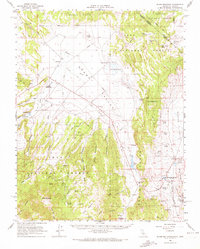
1962 Map of Glass Mountain
USGS Topo · Published 1972About this map
Adobe Valley serves as the central hub of this eastern California landscape, where high-desert ranching and mineral extraction met in the early 1960s. The map captures established operations such as the Adobe Ranch and Dutch Petes Ranch, while the presence of the Pizona (Site) indicates a location of earlier significance. To the southeast, the thermal waters of Benton Hot Springs mark a distinctive geological feature near the Benton Range.
Find a feature on this map
56 named features on this map. Tap any name to fly to it.
Don’t see what you’re looking for? This feature index may not catch every label — zoom into the map to look around manually.
Map Details
Editions of this 1962 Glass Mountain Map
2 editions found

Other maps of this area

1909 · Hawthorne
USGS Topo · 1:250,000

1911 · Hawthorne
USGS Topo · 1:250,000

1914 · Mt. Morrison
USGS Topo · 1:125,000

1915 · Hawthorne
USGS Topo · 1:250,000

1917 · White Mountain
USGS Topo · 1:125,000

1947 · Mariposa
USGS Topo · 1:250,000

1948 · Walker Lake
USGS Topo · 1:250,000

1948 · Mariposa
USGS Topo · 1:250,000

1953 · Mt. Morrison
USGS Topo · 1:62,500

1953 · Casa Diablo Mtn
USGS Topo · 1:62,500