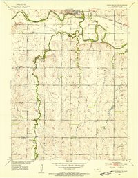
1953 Map of Glen Elder South
USGS Topo · Published 1954About this map
Glen Elder sits as the primary hub along the northern edge of this Mitchell County landscape, where the Solomon River meanders across the valley floor. The map documents a rural agrarian society organized around the section lines, with social life centered at country schools like Grellett Sch and Naomi Sch. The Missouri Pacific railroad parallels the river, connecting the elevators of the valley to wider markets, while the southern uplands are punctuated by small family and community burial grounds such as Fairview Cem and Excelsior Cem. This 1950s survey shows the area before significant changes to the hydrology of the Solomon Valley. The presence of numerous windmills and isolated gravel pits across the terrain speaks to the self-sufficient nature of the farms in Hayes and the surrounding townships during this period.
Find a feature on this map
26 named features on this map. Tap any name to fly to it.
Don’t see what you’re looking for? This feature index may not catch every label — zoom into the map to look around manually.
Map Details
Editions of this 1953 Glen Elder South Map
3 editions found
Other maps of this area

1894 · Mankato
USGS Topo · 1:125,000

1894 · Beloit
USGS Topo · 1:125,000

1953 · Solomon Rapids
USGS Topo · 1:24,000

1953 · Waconda Springs
USGS Topo · 1:24,000

1953 · Glen Elder South
USGS Topo · 1:24,000

1955 · Beloit
USGS Topo · 1:250,000

1959 · Beloit
USGS Topo · 1:250,000

1962 · Cawker City
USGS Topo · 1:24,000

1962 · Glen Elder North
USGS Topo · 1:24,000

1962 · Jewell SW
USGS Topo · 1:24,000