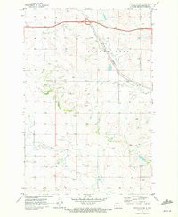
1970 Map of Glen Ullin SW
USGS Topo · Published 1972About this map
Eagle Nest rises as a prominent landmark in this prairie landscape of south-central North Dakota, where the Burlington Northern railroad cuts a diagonal path through the terrain. The survey captures a moment in the early 1970s when the region's agricultural character was defined by a grid of fence and field lines, many of which were visible from the air during the 1967 photogrammetric mapping. Significant water features like Heart Butte Creek and Big Muddy Cr shape the drainage patterns of the area, while smaller features such as a local Cem and numerous Gravel Pits indicate the practical footprints of rural life and industry. The presence of several Spring labels suggests the importance of natural water sources in this environment, supporting both the land and the sparse infrastructure of the Eagle Nest township.
Find a feature on this map
9 named features on this map. Tap any name to fly to it.
Don’t see what you’re looking for? This feature index may not catch every label — zoom into the map to look around manually.
Map Details
Editions of this 1970 Glen Ullin SW Map
This is the sole edition of this map. No revisions or reprints were ever made.
Other maps of this area

1938 · Heart Butte
USGS Topo · 1:48,000

1944 · Heart Butte
USGS Topo · 1:62,500

1953 · Dickinson
USGS Topo · 1:250,000

1954 · Bismarck
USGS Topo · 1:250,000

1957 · Dickinson
USGS Topo · 1:250,000

1958 · Bismarck
USGS Topo · 1:250,000

1960 · Glen Ullin
USGS Topo · 1:24,000

1960 · Heart Butte NW
USGS Topo · 1:24,000

1960 · Clark Butte NE
USGS Topo · 1:24,000

1960 · Heart Butte
USGS Topo · 1:24,000