
1960 Map of Glen Ullin
USGS Topo · Published 1962About this map
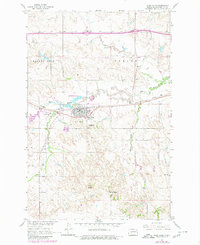
Glen Ullin serves as the central hub of this 1960 survey, situated at the confluence of the Northern Pacific railroad and a developing highway network. The landscape is defined by the winding paths of Big Muddy Creek and its tributaries, which carve through a terrain marked by distinctive high points like Horseshoe Butte, Rocky Ridge, and Spring Butte. This era captures a moment of significant infrastructure transition, with Interstate 94 Under Construction visible across the northern section of the map, promising new connectivity for the region.
Find a feature on this map
19 named features on this map. Tap any name to fly to it.
Don’t see what you’re looking for? This feature index may not catch every label — zoom into the map to look around manually.
Map Details
Editions of this 1960 Glen Ullin Map
2 editions found
Other maps of this area

1938 · Heart Butte
USGS Topo · 1:48,000

1944 · Heart Butte
USGS Topo · 1:62,500

1954 · Bismarck
USGS Topo · 1:250,000

1958 · Bismarck
USGS Topo · 1:250,000

1960 · Dengate
USGS Topo · 1:24,000

1960 · Heart Butte NW
USGS Topo · 1:24,000

1960 · Heart Butte
USGS Topo · 1:24,000

1970 · Hailstone Butte
USGS Topo · 1:24,000

1970 · Glen Ullin NE
USGS Topo · 1:24,000
1970 · Glen Ullin NW
USGS Topo · 1:24,000