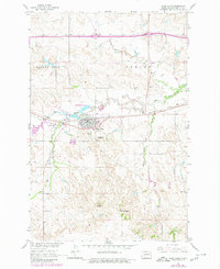
1960 Map of Glen Ullin
USGS Topo · Published 1980About this map
Glen Ullin serves as the primary hub of this North Dakota landscape, situated where the Northern Pacific railroad tracks and modern highway infrastructure intersect. The town's layout is clearly defined against the surrounding drainage systems of Big Muddy Creek and Haymarsh Creek, reflecting a settlement pattern tied to both the rail corridor and local water sources. To the west of the town center, the Glen Ullin State Game Management Area occupies a marshy stretch of the creek valley, while the Glen Ullin Airport provides aerial access to this prairie region.
Find a feature on this map
22 named features on this map. Tap any name to fly to it.
Don’t see what you’re looking for? This feature index may not catch every label — zoom into the map to look around manually.
Map Details
Editions of this 1960 Glen Ullin Map
2 editions found
Other maps of this area

1938 · Heart Butte
USGS Topo · 1:48,000

1944 · Heart Butte
USGS Topo · 1:62,500

1954 · Bismarck
USGS Topo · 1:250,000

1958 · Bismarck
USGS Topo · 1:250,000

1960 · Dengate
USGS Topo · 1:24,000

1960 · Glen Ullin
USGS Topo · 1:24,000

1960 · Heart Butte NW
USGS Topo · 1:24,000

1960 · Heart Butte
USGS Topo · 1:24,000

1970 · Hailstone Butte
USGS Topo · 1:24,000

1970 · Glen Ullin NE
USGS Topo · 1:24,000