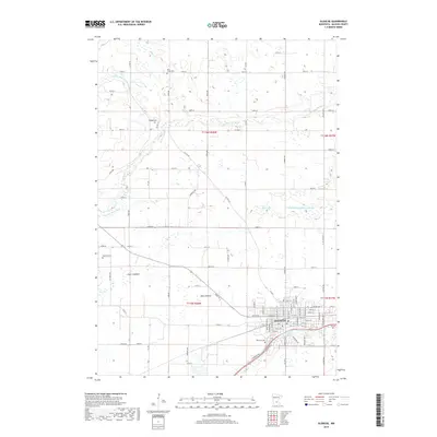
2019 Map of Glencoe
USGS Topo · Published 2019About this map
Glencoe serves as the primary hub in this central Minnesota landscape, where the town site is bounded by the winding course of Buffalo Cr and the waters of Beihoffer Lake. The surrounding terrain is defined by a complex drainage network, including the S Fork Crow River and multiple engineered channels like County Ditch Number Thirteen and County Ditch Number Twenty-six. The presence of large areas labeled as Swan Lakebed and Bog Lakebed indicates a transition from open water to marshy lowlands over time. For genealogists, the map preserves the exact locations of several rural burial grounds, including Bear Creek Cem, Koniska Cem, Getchell Cem, and Hillcrest Cem, which are scattered among the agricultural grid of county roads and section lines north and west of the city center.
Find a feature on this map
91 named features on this map. Tap any name to fly to it.
Don’t see what you’re looking for? This feature index may not catch every label — zoom into the map to look around manually.
Map Details
Editions of this 2019 Glencoe Map
This is the sole edition of this map. No revisions or reprints were ever made.
Other maps of this area

1953 · New Ulm
USGS Topo · 1:250,000

1957 · New Ulm
USGS Topo · 1:250,000

1958 · New Ulm
USGS Topo · 1:250,000

1958 · Gaylord
USGS Topo · 1:62,500

1958 · Glencoe
USGS Topo · 1:62,500

1958 · Winthrop
USGS Topo · 1:62,500

1958 · Hutchinson
USGS Topo · 1:62,500

1967 · New Ulm
USGS Topo · 1:250,000
1982 · Silver Lake
USGS Topo · 1:24,000
1982 · Plato
USGS Topo · 1:24,000