
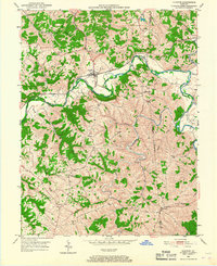
1950 Map of Glencoe
USGS Topo · Published 1952About this map
Eagle Creek snakes through the center of this 1950s survey, marking the jagged boundary where Gallatin, Owen, and Grant Counties converge. The village of Glencoe serves as a primary hub for this rural corridor, situated along the Louisville and Nashville railroad line and the winding waters of Big Sugar Creek. The landscape is defined by its dendritic drainage patterns, with numerous named branches like Hodge Branch and Moseby Branch carving into the upland plateaus.
Find a feature on this map
39 named features on this map. Tap any name to fly to it.
Don’t see what you’re looking for? This feature index may not catch every label — zoom into the map to look around manually.
Map Details
Editions of this 1950 Glencoe Map
2 editions found
Other maps of this area

1943 · Florence
USGS Topo · 1:24,000

1943 · Patriot
USGS Topo · 1:24,000

1950 · New Liberty
USGS Topo · 1:24,000

1950 · Elliston
USGS Topo · 1:24,000

1950 · Owenton
USGS Topo · 1:24,000

1950 · Verona
USGS Topo · 1:24,000

1950 · Lawrenceville
USGS Topo · 1:24,000

1951 · Florence
USGS Topo · 1:24,000

1951 · Sanders
USGS Topo · 1:24,000
1951 · Patriot
USGS Topo · 1:24,000