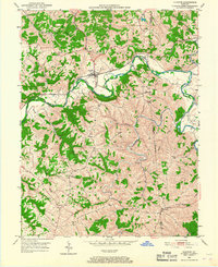
1950 Map of Glencoe
USGS Topo · Published 1967About this map
Glencoe serves as the central hub of this mid-century survey, situated at the intersection of a winding Eagle Creek and the Louisville and Nashville railroad line. The landscape is defined by the sharp relief of northern Kentucky, where narrow ridges separate deep-cut valleys such as Brush Creek and Buffalo Creek. This topography influenced a dispersed settlement pattern, with small communities like Bromley and Jonesville connected by ridge-top roads.
Find a feature on this map
31 named features on this map. Tap any name to fly to it.
Don’t see what you’re looking for? This feature index may not catch every label — zoom into the map to look around manually.
Map Details
Editions of this 1950 Glencoe Map
2 editions found
Other maps of this area

1943 · Florence
USGS Topo · 1:24,000

1943 · Patriot
USGS Topo · 1:24,000

1950 · New Liberty
USGS Topo · 1:24,000

1950 · Glencoe
USGS Topo · 1:24,000

1950 · Elliston
USGS Topo · 1:24,000

1950 · Owenton
USGS Topo · 1:24,000

1950 · Verona
USGS Topo · 1:24,000

1950 · Lawrenceville
USGS Topo · 1:24,000

1951 · Florence
USGS Topo · 1:24,000

1951 · Sanders
USGS Topo · 1:24,000