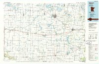
1986 Map of Glencoe
USGS Topo · Published 1986About this map
Hutchinson and Glencoe anchor this mid-1980s survey of south-central Minnesota, where a dense grid of township roads and section lines defines the agricultural heartland. The landscape is characterized by its numerous glacial lakes, including Lake Lillian and Big Kandiyohi Lake, and the extensive network of wildlife management areas like Halva State Wildlife Management Area and Greenleaf State Wildlife Management Area.
Find a feature on this map
102 named features on this map. Tap any name to fly to it.
Don’t see what you’re looking for? This feature index may not catch every label — zoom into the map to look around manually.
Map Details
Editions of this 1986 Glencoe Map
2 editions found
Other maps of this area

1952 · Morton
USGS Topo · 1:62,500

1952 · Redwood Falls
USGS Topo · 1:62,500

1953 · Morgan
USGS Topo · 1:62,500

1953 · Saint Paul
USGS Topo · 1:250,000

1953 · New Ulm
USGS Topo · 1:250,000

1953 · Saint Cloud
USGS Topo · 1:250,000

1953 · Stillwater
USGS Topo · 1:250,000

1955 · Stillwater
USGS Topo · 1:250,000

1956 · Atwater
USGS Topo · 1:62,500

1957 · Saint Cloud
USGS Topo · 1:250,000