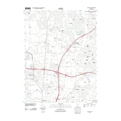
2010 Map of Glendale
USGS Topo · Published 2010About this map
Mill Creek and its various forks dictate the geography of this suburban corridor during the early 2000s, winding through established communities and new developments. The map highlights a high density of burial grounds essential for local genealogy, ranging from the Old Saint Marys Cemetery in Springdale to the Coleman Cemetery near Sharonville. The area's transition from agricultural roots to a modern commerce hub is evident in the numerous office parks like the Triangle Office Park and Schumacher Commerce Park situated alongside residential neighborhoods such as Beckett Ridge and Concord Hills. Outdoor recreation and conservation are well-represented by the expansive Sharon Woods and Sharon Lake, while smaller landmarks like the West Chester Post Office and Saint Edmunds Camp provide specific points of interest for historical research. The complex network of roads, including Glendale-Milford Rd and Tylersville Rd, illustrates the rapid connectivity defining the region's 21st-century growth.
Find a feature on this map
113 named features on this map. Tap any name to fly to it.
Don’t see what you’re looking for? This feature index may not catch every label — zoom into the map to look around manually.
Map Details
Editions of this 2010 Glendale Map
This is the sole edition of this map. No revisions or reprints were ever made.
Other maps of this area

1898 · East Cincinnati
USGS Topo · 1:62,500

1904 · Mason
USGS Topo · 1:62,500

1906 · Mason
USGS Topo · 1:62,500

1914 · East Cincinnati
USGS Topo · 1:62,500

1914 · West Cincinnati
USGS Topo · 1:62,500

1915 · Hamilton
USGS Topo · 1:62,500

1917 · Hamilton
USGS Topo · 1:62,500
1953 · Madeira
USGS Topo · 1:24,000
1953 · Cincinnati East
USGS Topo · 1:24,000

1953 · Cincinnati West
USGS Topo · 1:24,000