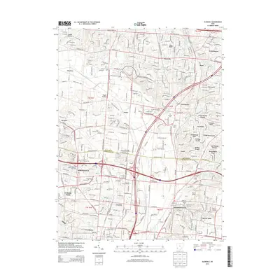
2013 Map of Glendale
USGS Topo · Published 2013About this map
The boundary between Butler and Hamilton Counties divides a landscape defined by significant suburban development and established residential enclaves north of Cincinnati. Glendale and Springdale anchor the southwestern portion of the sheet, while Sharonville and Blue Ash occupy the southeast. The natural geography is centered on the drainage of Mill Creek and its various branches, including the East Fork Mill Creek, which wind through industrial corridors and parks. The large recreational expanse of Sharon Woods, featuring Sharon Lake, serves as a prominent green space amidst the grid of major thoroughfares like Princeton Glendale Road and East Kemper Road. Smaller, historic place names such as Port Union, Rialto, and Gano persist in the margins of newer developments like Westchester and Circle View Acres. Educational institutions, including the Art Institute of Cincinnati, reflect the area's modern identity, while numerous cemeteries like Oak Hill and Stockton provide a link to the region's earlier heritage.
Find a feature on this map
67 named features on this map. Tap any name to fly to it.
Don’t see what you’re looking for? This feature index may not catch every label — zoom into the map to look around manually.
Map Details
Editions of this 2013 Glendale Map
This is the sole edition of this map. No revisions or reprints were ever made.
Other maps of this area

1898 · East Cincinnati
USGS Topo · 1:62,500

1904 · Mason
USGS Topo · 1:62,500

1906 · Mason
USGS Topo · 1:62,500

1914 · East Cincinnati
USGS Topo · 1:62,500

1914 · West Cincinnati
USGS Topo · 1:62,500

1915 · Hamilton
USGS Topo · 1:62,500

1917 · Hamilton
USGS Topo · 1:62,500
1953 · Madeira
USGS Topo · 1:24,000
1953 · Cincinnati East
USGS Topo · 1:24,000

1953 · Cincinnati West
USGS Topo · 1:24,000