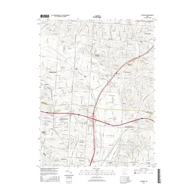
2016 Map of Glendale
USGS Topo · Published 2016About this map
Mill Creek and its tributaries carve through this densely developed corridor along the Butler and Hamilton County line, where suburban growth meets established commercial centers. The landscape is defined by its transportation network, from the wide bypasses of Princeton Glendale Rd to the industrial clusters at Crescentville and Rialto. Higher education and specialized campuses, including Bohecker College-Cincinnati and The Art Institute of Cincinnati, are woven into the urban fabric alongside long-standing community markers. Genealogists will find several small historic burial grounds interspersed among residential developments and business parks, such as Old Saint Marys Cem and Stockton Cem. The presence of the Sharonville Retention Reservoir and the winding East Fork Mill Creek indicates the ongoing importance of water management in this heavily built-up suburban expanse north of Cincinnati.
Find a feature on this map
61 named features on this map. Tap any name to fly to it.
Don’t see what you’re looking for? This feature index may not catch every label — zoom into the map to look around manually.
Map Details
Editions of this 2016 Glendale Map
This is the sole edition of this map. No revisions or reprints were ever made.
Other maps of this area

1898 · East Cincinnati
USGS Topo · 1:62,500

1904 · Mason
USGS Topo · 1:62,500

1906 · Mason
USGS Topo · 1:62,500

1914 · East Cincinnati
USGS Topo · 1:62,500

1914 · West Cincinnati
USGS Topo · 1:62,500

1915 · Hamilton
USGS Topo · 1:62,500

1917 · Hamilton
USGS Topo · 1:62,500
1953 · Madeira
USGS Topo · 1:24,000
1953 · Cincinnati East
USGS Topo · 1:24,000

1953 · Cincinnati West
USGS Topo · 1:24,000