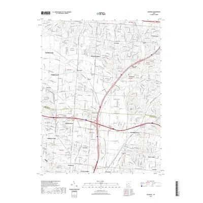
2019 Map of Glendale
USGS Topo · Published 2019About this map
Mill Creek and its various branches, including the E Fork Mill Cr and W Fork Mill Cr, provide the geographical spine for this densely developed corridor between Hamilton and Sharonville. The landscape is a complex assembly of suburban expansion and historic hamlets, where places like Port Union, Rialto, and Crescentville sit alongside modern educational centers such as ATA College and The Art Institute of Cincinnati. This 2019 survey documents a highly interconnected region defined by the intersection of I-75 and I-275, which has transformed former agricultural lands into the residential and commercial hubs of Beckett Ridge and Westchester. Despite this growth, numerous small burial grounds are preserved across the quadrangle, including the Old Saint Marys Cem and Stockton Cem, offering tangible links to the 19th-century families who first settled these township sections.
Find a feature on this map
52 named features on this map. Tap any name to fly to it.
Don’t see what you’re looking for? This feature index may not catch every label — zoom into the map to look around manually.
Map Details
Editions of this 2019 Glendale Map
This is the sole edition of this map. No revisions or reprints were ever made.
Other maps of this area

1898 · East Cincinnati
USGS Topo · 1:62,500

1904 · Mason
USGS Topo · 1:62,500

1906 · Mason
USGS Topo · 1:62,500

1914 · East Cincinnati
USGS Topo · 1:62,500

1914 · West Cincinnati
USGS Topo · 1:62,500

1915 · Hamilton
USGS Topo · 1:62,500

1917 · Hamilton
USGS Topo · 1:62,500
1953 · Madeira
USGS Topo · 1:24,000
1953 · Cincinnati East
USGS Topo · 1:24,000

1953 · Cincinnati West
USGS Topo · 1:24,000