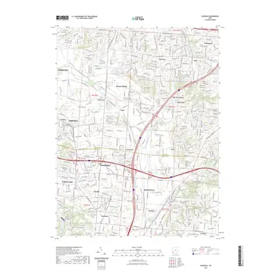
2023 Map of Glendale
USGS Topo · Published 2023About this map
Mill Creek and its various forks define the drainage and development patterns of this portion of southwest Ohio, where suburban growth meets established industrial corridors. The geography is marked by a concentration of distinct communities including Springdale, Sharonville, and Evendale. Historically significant sites for genealogists include Old Saint Marys Cem, Brookside Cem, and Rest Haven Memorial Park, alongside smaller burial grounds like Smeizer Cem. The map illustrates the contemporary road network, dominated by Reading Rd and Springfield Pike, which connect the older cores of Glendale and Woodlawn with newer residential developments such as Beckett Ridge and Wetherington. Significant educational and civic facilities, such as Fortis College - Cincinnati and the Butler County Courthouse Annex, highlight the area's role as a regional hub of activity between larger urban centers.
Find a feature on this map
59 named features on this map. Tap any name to fly to it.
Don’t see what you’re looking for? This feature index may not catch every label — zoom into the map to look around manually.
Map Details
Editions of this 2023 Glendale Map
This is the sole edition of this map. No revisions or reprints were ever made.
Other maps of this area

1898 · East Cincinnati
USGS Topo · 1:62,500

1904 · Mason
USGS Topo · 1:62,500

1906 · Mason
USGS Topo · 1:62,500

1914 · East Cincinnati
USGS Topo · 1:62,500

1914 · West Cincinnati
USGS Topo · 1:62,500

1915 · Hamilton
USGS Topo · 1:62,500

1917 · Hamilton
USGS Topo · 1:62,500
1953 · Madeira
USGS Topo · 1:24,000
1953 · Cincinnati East
USGS Topo · 1:24,000

1953 · Cincinnati West
USGS Topo · 1:24,000