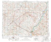
1954 Map of Glendive
USGS Topo · Published 1976About this map
Glendive serves as a regional hub in this mid-century survey of eastern Montana, where the Yellowstone River and Burlington Northern railroad lines converge. The landscape is defined by vast tables and heights, including the distinct terrain of Big Sheep Mountain and McCone Heights. Evidence of rural community life is found in isolated institutions like Golden Valley School and Hay Creek School, while Makoshika State Park marks the badlands topography south of the county seat.
Find a feature on this map
69 named features on this map. Tap any name to fly to it.
Don’t see what you’re looking for? This feature index may not catch every label — zoom into the map to look around manually.
Map Details
Editions of this 1954 Glendive Map
2 editions found

Other maps of this area

1909 · Glendive
USGS Topo · 1:250,000

1912 · Chelsea
USGS Topo · 1:62,500

1912 · Poplar
USGS Topo · 1:62,500

1914 · Brockton
USGS Topo · 1:62,500

1915 · Frazer
USGS Topo · 1:62,500

1915 · Oswego
USGS Topo · 1:62,500

1916 · Wolf Point
USGS Topo · 1:62,500

1953 · Miles City
USGS Topo · 1:250,000

1953 · Williston
USGS Topo · 1:250,000

1953 · Dickinson
USGS Topo · 1:250,000