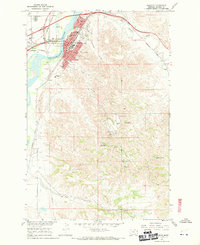
1967 Map of Glendive
USGS Topo · Published 1970About this map
The Yellowstone River cuts through this landscape, defining the character of Glendive during a period of mid-century growth. As the seat of Dawson County, the city shows a concentrated municipal core featuring the Courthouse and several educational institutions, including Dawson Co Jr College, County High Sch, and Jefferson Sch. The Northern Pacific railroad tracks parallel the river, supporting the local economy alongside irrigation infrastructure like the Main Canal.
Find a feature on this map
39 named features on this map. Tap any name to fly to it.
Don’t see what you’re looking for? This feature index may not catch every label — zoom into the map to look around manually.
Map Details
Editions of this 1967 Glendive Map
2 editions found
Other maps of this area

1909 · Glendive
USGS Topo · 1:250,000

1953 · Miles City
USGS Topo · 1:250,000

1954 · Glendive
USGS Topo · 1:250,000

1957 · Miles City
USGS Topo · 1:250,000

1957 · Glendive
USGS Topo · 1:250,000

1958 · Miles City
USGS Topo · 1:250,000

1958 · Glendive
USGS Topo · 1:250,000

1967 · Stipek
USGS Topo · 1:24,000

1967 · Allard
USGS Topo · 1:24,000

1967 · Belle Prairie
USGS Topo · 1:24,000
Featured Places
- Glendive, MT
- Spring Grove Trailer Court, MT
- Curry, MT
- Highland Mobile Home Park, MT
- Casitas Del Rio, Glendive