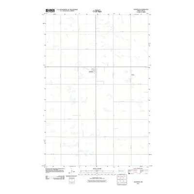
2011 Map of Glenfield
USGS Topo · Published 2011About this map
Glenfield serves as the central hub for this Foster County landscape, which is defined by a grid-like pattern of rural roads and scattered prairie potholes. The settlement is anchored by a small network of streets including Church Ave and Main St E, reflecting the organized land management of the North Dakota plains. The Glenfield Cemetery, located just east of the main town site along 95th Ave NE, offers a significant point of interest for genealogists researching families from this agricultural region. Outside of the primary settlement, the terrain is sparsely populated, dominated by section-line roads such as 5th St NE and 91st Ave SE that separate large tracts of farm and wetland.
Find a feature on this map
18 named features on this map. Tap any name to fly to it.
Don’t see what you’re looking for? This feature index may not catch every label — zoom into the map to look around manually.
Map Details
Editions of this 2011 Glenfield Map
This is the sole edition of this map. No revisions or reprints were ever made.
Other maps of this area

1900 · Pingree
USGS Topo · 1:125,000

1951 · Kensal
USGS Topo · 1:24,000

1951 · Kensal NW
USGS Topo · 1:24,000

1951 · Kensal SE
USGS Topo · 1:24,000

1951 · Glenfield
USGS Topo · 1:24,000

1952 · New Rockford
USGS Topo · 1:250,000

1956 · New Rockford
USGS Topo · 1:250,000

1961 · McHenry
USGS Topo · 1:24,000
1961 · Juanita
USGS Topo · 1:24,000

1961 · Sutton
USGS Topo · 1:24,000