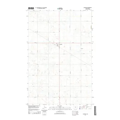
2014 Map of Glenfield
USGS Topo · Published 2014About this map
Glenfield serves as the central hub of this prairie landscape in Foster County, situated at the intersection of ND-200 and ND-20. The town's grid is small but distinct, featuring streets like Main St E and School Ave that anchor the local community. To the east of the primary settlement lies the Glenfield Cem, a critical site for genealogists and local historians tracing family lineages in this portion of the Dakotas. The surrounding terrain is defined by a dense network of sectional roads, including 95th Ave NE and 5th St NE, which reflect the region's agricultural organization. This survey documents the area's geography in the early twenty-first century, showcasing a landscape where transportation corridors and small-town infrastructure are precisely integrated into the Great Plains' expansive topography.
Find a feature on this map
21 named features on this map. Tap any name to fly to it.
Don’t see what you’re looking for? This feature index may not catch every label — zoom into the map to look around manually.
Map Details
Editions of this 2014 Glenfield Map
This is the sole edition of this map. No revisions or reprints were ever made.
Other maps of this area

1900 · Pingree
USGS Topo · 1:125,000

1951 · Kensal
USGS Topo · 1:24,000

1951 · Kensal NW
USGS Topo · 1:24,000

1951 · Kensal SE
USGS Topo · 1:24,000

1951 · Glenfield
USGS Topo · 1:24,000

1952 · New Rockford
USGS Topo · 1:250,000

1956 · New Rockford
USGS Topo · 1:250,000

1961 · McHenry
USGS Topo · 1:24,000
1961 · Juanita
USGS Topo · 1:24,000

1961 · Sutton
USGS Topo · 1:24,000