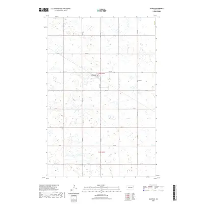
2020 Map of Glenfield
USGS Topo · Published 2020About this map
Glenfield occupies a central position within this portion of Foster County, serving as a focal point for the surrounding prairie landscape. The town is structured around a traditional grid system, with Main St E and several numbered streets such as 5th St NE and 1st St SE defining its layout. This organization reflects the agrarian planning common across North Dakota, where small settlements were positioned to support regional farming operations. A short distance east of the town center lies the Glenfield Cem, a significant site for local genealogical research and community history. The surrounding terrain is marked by the township and range divisions of t146n r62w and t145n r62w, showing the enduring influence of the Public Land Survey System on the rural landscape.
Find a feature on this map
13 named features on this map. Tap any name to fly to it.
Don’t see what you’re looking for? This feature index may not catch every label — zoom into the map to look around manually.
Map Details
Editions of this 2020 Glenfield Map
This is the sole edition of this map. No revisions or reprints were ever made.
Other maps of this area

1900 · Pingree
USGS Topo · 1:125,000

1951 · Kensal
USGS Topo · 1:24,000

1951 · Kensal NW
USGS Topo · 1:24,000

1951 · Kensal SE
USGS Topo · 1:24,000

1951 · Glenfield
USGS Topo · 1:24,000

1952 · New Rockford
USGS Topo · 1:250,000

1956 · New Rockford
USGS Topo · 1:250,000

1961 · McHenry
USGS Topo · 1:24,000
1961 · Juanita
USGS Topo · 1:24,000

1961 · Sutton
USGS Topo · 1:24,000