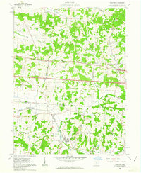
1961 Map of Glenford
USGS Topo · Published 1963About this map
The Licking and Perry County borderlands in the early 1960s reveal a landscape of glacial terrain and early industrial activity. Near the village of Glenford, the confluence of two major rail lines — the Baltimore and Ohio and the New York Central — underscores the region's importance as a transportation corridor. The map highlights a transition between historical land systems, noted by the North Lands and South Lands boundary, which separates the United States Military District from Congress Lands. Ancient and natural landmarks like the Indian Mound and the distinctive heights of Buzzard Glory Knob and Eagle Nest Hill rise above the drainage basins of Jonathan Creek and Claylick Creek. Scattered oil wells across the townships indicate the energy extraction shaping the local economy alongside rural communities such as Brownsville and Linnville.
Find a feature on this map
39 named features on this map. Tap any name to fly to it.
Don’t see what you’re looking for? This feature index may not catch every label — zoom into the map to look around manually.
Map Details
Editions of this 1961 Glenford Map
3 editions found
Other maps of this area

1909 · Newark
USGS Topo · 1:62,500

1909 · Thornville
USGS Topo · 1:62,500

1910 · Frazeysburg
USGS Topo · 1:62,500

1910 · Zanesville
USGS Topo · 1:62,500

1947 · Columbus
USGS Topo · 1:250,000

1950 · Marion
USGS Topo · 1:250,000

1961 · Columbus
USGS Topo · 1:250,000

1961 · Hanover
USGS Topo · 1:24,000

1961 · Newark
USGS Topo · 1:24,000

1961 · Rushville
USGS Topo · 1:24,000