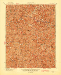
1928 Map of Glenville
USGS Topo · Published 1945About this map
The Little Kanawha River snakes through the heart of Gilmer County, anchoring a landscape defined by its dense network of small rural schools and isolated settlements. In this 1920s era, education was decentralized, as evidenced by dozens of local institutions like the De Kalb School, Peachtree School, and Sugar Grove School serving families in the surrounding hollows. The topography is tightly packed with named runs and forks, such as Wolfpen Run and Hardman Fork, which dictated the early road patterns connecting Glenville to outlying communities like Stumptown and Normantown. These winding paths often converged at distinct landmarks like Letter Gap or community centers such as Poplar Tree Church. The map provides a detailed look at the interface between Gilmer and Braxton Counties, showing a period when the river-and-road economy supported numerous small hubs including Cedarville and Sand Fork.
Find a feature on this map
132 named features on this map. Tap any name to fly to it.
Don’t see what you’re looking for? This feature index may not catch every label — zoom into the map to look around manually.
Map Details
Editions of this 1928 Glenville Map
2 editions found
Other maps of this area

1893 · Sutton
USGS Topo · 1:125,000

1904 · Vadis
USGS Topo · 1:62,500

1906 · Holbrook
USGS Topo · 1:62,500

1906 · Glenville
USGS Topo · 1:62,500

1906 · Burnsville
USGS Topo · 1:62,500

1906 · Otter
USGS Topo · 1:62,500

1907 · Otter
USGS Topo · 1:62,500

1907 · Harrisville
USGS Topo · 1:62,500

1907 · Arnoldsburg
USGS Topo · 1:62,500

1908 · Gassaway
USGS Topo · 1:48,000