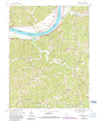
1968 Map of Glenwood
USGS Topo · Published 1990About this map
The Ohio River forms the vital western boundary of this riverfront territory, where the small community of Glenwood serves as a focal point along the West Virginia shore. The landscape rises sharply from the riverbanks into the wooded hills of the Wayne National Forest, revealing a complex network of ridges and hollows such as Barker Ridge and Big Hill Hollow. Settled life follows the winding watercourses of Guyan Creek and Eighteenmile Creek, where country schools like Meadowfield Sch and Beech Grove Sch once anchored rural neighborhoods.
Find a feature on this map
62 named features on this map. Tap any name to fly to it.
Don’t see what you’re looking for? This feature index may not catch every label — zoom into the map to look around manually.
Map Details
Editions of this 1968 Glenwood Map
2 editions found
Other maps of this area

1892 · Huntington
USGS Topo · 1:125,000

1898 · Huntington
USGS Topo · 1:125,000

1901 · Guyandot
USGS Topo · 1:62,500

1902 · Guyandot
USGS Topo · 1:62,500

1902 · Milton
USGS Topo · 1:62,500

1906 · Athalia
USGS Topo · 1:62,500

1906 · Glenwood
USGS Topo · 1:62,500

1908 · Athalia
USGS Topo · 1:62,500

1908 · Glenwood
USGS Topo · 1:62,500

1931 · Milton
USGS Topo · 1:62,500