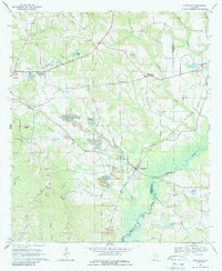
1968 Map of Glenwood
USGS Topo · Published 1987About this map
The Conecuh River winds through the southern landscape of this 1960s survey, marking a region defined by agricultural crossroads and burgeoning industrial activity. At Glenwood, the Central of Georgia railroad creates a hub for local commerce, while the surrounding terrain is punctuated by significant extractive activity at several locations marked as Strip Mine. The map reveals a dense network of spiritual and communal centers, including Star Hope Ch, Athens Ch, and Bethel Ch, alongside rural nodes like Social Town and Shirleys Crossroads.
Find a feature on this map
51 named features on this map. Tap any name to fly to it.
Don’t see what you’re looking for? This feature index may not catch every label — zoom into the map to look around manually.
Map Details
Editions of this 1968 Glenwood Map
2 editions found
Other maps of this area

1953 · Andalusia
USGS Topo · 1:250,000

1957 · Andalusia
USGS Topo · 1:250,000
1968 · Goshen
USGS Topo · 1:24,000
1968 · Youngblood
USGS Topo · 1:24,000
1968 · Bluff Springs
USGS Topo · 1:24,000

1968 · Glenwood
USGS Topo · 1:24,000

1968 · Bullock
USGS Topo · 1:24,000

1968 · Petrey
USGS Topo · 1:24,000

1971 · Luverne
USGS Topo · 1:24,000

1971 · Brantley
USGS Topo · 1:24,000