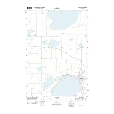
2010 Map of Glenwood
USGS Topo · Published 2010About this map
Lake Minnewaska dominates the southern landscape of this Pope County survey, where the city of Glenwood serves as a local hub. The map captures a transition between the established lakeside community and the surrounding agricultural grid, punctuated by a dense network of local cemeteries like Swedish Mission Cemetery and Saint John's Cemetery that offer vital clues for genealogical research. Shoreline development is evident at Long Beach and near Woodlawn Resort and Campground, reflecting the area's long-standing role as a recreational destination. The northern reach is defined by Lake Reno, while smaller basins like Ann Lake and John Lake dot the interior. Water management is visible through engineered features such as the Pelican Lake Inlet Dam and Judicial Ditch Number Three, which demonstrate how the natural hydrology has been adapted for local land use. Local landmarks like the Pope County Fairgrounds and Glenwood Post Office ground the map in the civic life of the era.
Find a feature on this map
67 named features on this map. Tap any name to fly to it.
Don’t see what you’re looking for? This feature index may not catch every label — zoom into the map to look around manually.
Map Details
Editions of this 2010 Glenwood Map
This is the sole edition of this map. No revisions or reprints were ever made.
Other maps of this area

1953 · Saint Cloud
USGS Topo · 1:250,000

1957 · Saint Cloud
USGS Topo · 1:250,000

1958 · Saint Cloud
USGS Topo · 1:250,000

1966 · Farwell
USGS Topo · 1:24,000

1966 · Lake Mary
USGS Topo · 1:24,000

1966 · Forada
USGS Topo · 1:24,000

1968 · Starbuck
USGS Topo · 1:24,000

1968 · Lowry
USGS Topo · 1:24,000

1968 · Glenwood
USGS Topo · 1:24,000

1968 · Terrace
USGS Topo · 1:24,000