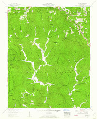
1959 Map of Globe
USGS Topo · Published 1962About this map
Pisgah National Forest and the Daniel Boone Wildlife Management Area dominate this section of the Blue Ridge, where the headwaters of the Johns River descend through deep gaps and hollows. The settlement of Globe sits at the confluence of several mountain branches, serving as a focal point for local history with the Globe Ch and Globe Cem. The map reveals a landscape defined by family history, evidenced by numerous burial grounds such as McLean Cem, Moore Cem, and Gregg Cem tucked away on the slopes. In the northern reaches, the edge of Blowing Rock and Moses H Cone Memorial Park mark the transition toward the high crests of the Blue Ridge. The geography is characterized by prominent ridges like Backbone Ridge and Wilson Ridge, which directed the early road networks and established the boundaries for the mountain communities found here in the late 1950s.
Find a feature on this map
125 named features on this map. Tap any name to fly to it.
Don’t see what you’re looking for? This feature index may not catch every label — zoom into the map to look around manually.
Map Details
Editions of this 1959 Globe Map
3 editions found
Other maps of this area

1893 · Cranberry
USGS Topo · 1:125,000

1895 · Cranberry
USGS Topo · 1:125,000

1899 · Cranberry
USGS Topo · 1:125,000

1902 · Cranberry
USGS Topo · 1:125,000

1905 · Morganton
USGS Topo · 1:125,000

1934 · Valle Crucis
USGS Topo · 1:24,000

1934 · Boone
USGS Topo · 1:24,000

1936 · Blowing Rock
USGS Topo · 1:48,000

1942 · Blowing Rock
USGS Topo · 1:62,500

1944 · Linville
USGS Topo · 1:62,500