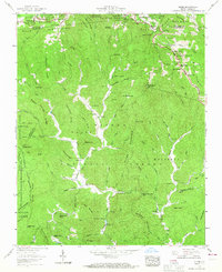
1959 Map of Globe
USGS Topo · Published 1967About this map
Globe and the surrounding mountain ridges of the Pisgah National Forest characterize this mid-century survey along the Watauga and Caldwell County line. The landscape is defined by the steep terrain of the Blue Ridge, where numerous family-named cemeteries such as Tolbert Cem, McLean Cem, and Herman Cem suggest a history of isolated family homesteads. The Yadkin River and Johns River drain the high country, with small settlements like Upton and Bailey situated along narrow valley floors.
Find a feature on this map
133 named features on this map. Tap any name to fly to it.
Don’t see what you’re looking for? This feature index may not catch every label — zoom into the map to look around manually.
Map Details
Editions of this 1959 Globe Map
3 editions found
Other maps of this area

1893 · Cranberry
USGS Topo · 1:125,000

1895 · Cranberry
USGS Topo · 1:125,000

1899 · Cranberry
USGS Topo · 1:125,000

1902 · Cranberry
USGS Topo · 1:125,000

1905 · Morganton
USGS Topo · 1:125,000

1934 · Valle Crucis
USGS Topo · 1:24,000

1934 · Boone
USGS Topo · 1:24,000

1936 · Blowing Rock
USGS Topo · 1:48,000

1942 · Blowing Rock
USGS Topo · 1:62,500

1944 · Linville
USGS Topo · 1:62,500