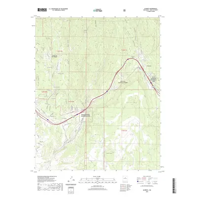
2020 Map of Glorieta
USGS Topo · Published 2020About this map
Glorieta Pass serves as a central corridor through the Sangre de Cristo foothills, anchoring a landscape where mountain peaks meet high mesas. The village of Glorieta lies at the junction of modern transit routes and traditional mountain paths, including the Old Las Vegas Hwy. The area is geographically defined by the massive Glorieta Mesa to the south and the high elevations of Glorieta Baldy and Shaggy Peak to the north. These heights overlook the drainage of Galisteo Creek and several rugged canyons, including Apache Canyon and Ruiz Canyon. Cultural and historical continuity is represented by the Pecos National Historical Park and local landmarks like the Cañoncito Cem and Glorieta Cem, which provide essential points of reference for genealogists and local historians studying this Santa Fe County corridor.
Find a feature on this map
79 named features on this map. Tap any name to fly to it.
Don’t see what you’re looking for? This feature index may not catch every label — zoom into the map to look around manually.
Map Details
Editions of this 2020 Glorieta Map
This is the sole edition of this map. No revisions or reprints were ever made.
Other maps of this area

1889 · Santa Fe
USGS Topo · 1:125,000

1894 · Santa Fe
USGS Topo · 1:125,000

1894 · Lamy
USGS Topo · 1:125,000

1952 · Santa Fe
USGS Topo · 1:24,000

1952 · Seton Village
USGS Topo · 1:24,000

1953 · Glorieta
USGS Topo · 1:24,000

1953 · Mc Clure Reservoir
USGS Topo · 1:24,000

1954 · Santa Fe
USGS Topo · 1:250,000

1958 · Santa Fe
USGS Topo · 1:250,000
1961 · Santa Fe
USGS Topo · 1:24,000